The Village & the Valley
The valley is closed at its lower end by the reservoir, whose construction at some point in the past drowned around forty acres of older settlement. A framed map of the valley hangs above the dartboard at The Rail and Reservoir showing villages that now exist only as names on the chart. Their names are not given in the text.
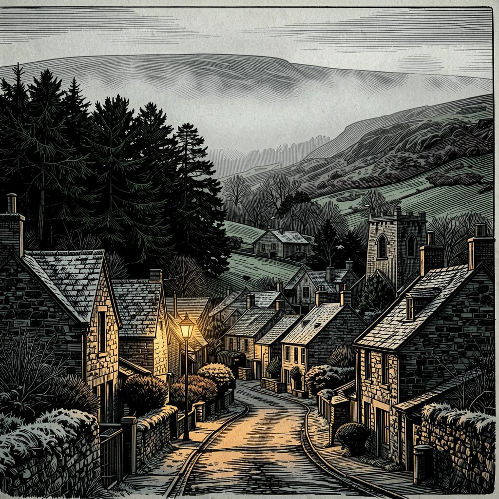
The valley road runs roughly along the contour, with the older village buildings clustered on the gentler southern slope. The High Street carries the small concentration of village commerce — the post office, the village green and its churchyard, the pub. Behind and above this strip of frontages, terraced stone houses climb the slope on a small network of lanes; Haversage Road is one of these. The valley walls above the buildings turn quickly to open hill-grazing; the lane out at the head of the village climbs steeply onto the moor.
Above the village, the high ground is The Ridge: a walked spine of moorland from which the valley unfurls behind the walker in patches of green, grey and the dark of evergreens along the field boundaries. This is the country in which much of the family's and the saga's outdoor business is conducted.
History
The Battle of Hope, 926 AD
The foundation of Hope's End is traditionally fixed at 926 AD, in the immediate aftermath of one of the more obscure but consequential military engagements of King Æthelstan's northern campaign. Æthelstan, grandson of Alfred the Great and arguably the first king of all the English, had inherited a kingdom whose northern frontier was contested by a loose coalition of Scots, Strathclyde Britons (the ‘Celts’ of later chronicle), and Hiberno-Norse Vikings out of the Five Boroughs of the Danelaw. The 926 campaign — the precursor to the more famous Treaty of Eamont Bridge of July 927, by which the northern kings formally submitted to Æthelstan's overlordship — was the consolidation of West Saxon control over the Mercian and Northumbrian fringe, of which the central Peak District was a contested edge.
The engagement remembered in Peak District folklore as the Battle of Hope was fought in the wide ground of the Hope Valley below the twin peaks of Win Hill and Lose Hill. The local tradition surrounding the two hills — that two armies camped on each, that whoever held the higher and more defensible position would win and whoever held the lower would lose, and that the hills are named for the result — in the Aethereal Stories universe attaches specifically to this engagement. Æthelstan's main force, dispatched north from Mercia, engaged the coalition's main body on the valley floor near the village of Hope. The opposing army had positioned its main encampment on Lose Hill.
The high plateau west of Mam Tor — the future site of Hope's End — was the geographical key to the engagement. Two roles were assigned to its garrison troops by Æthelstan's commanders. First, the plateau commanded the only practical route by which the coalition might be reinforced from the west, through the ancient passes connecting the central Peak to the Cheshire plain; holding the plateau meant blocking those passes and preventing relief from reaching the coalition's main body. Second, and decisively, the plateau commanded the head of Winnats Pass — the only route by which the army on Lose Hill, if defeated, could escape westward toward the open moorland and the Cheshire border. To hold the plateau was to close the western gate.
The battle's outcome on the valley floor was a West Saxon victory; the Lose Hill army broke, and the survivors fled west, away from the pursuing main force and toward the perceived sanctuary of the moors beyond. They were funnelled by the ground into Castleton and then up into the limestone cleft of Winnats Pass, climbing under fire toward what they assumed was open country at the top of the gorge. The garrison on the plateau was waiting. The fleeing army was bottlenecked in the steep, narrow gorge between Æthelstan's pursuing main force at its eastern mouth and the garrison troops blocking its western head, and was, by the chronicler's account, completely destroyed there.
Hope's End originates, on this reading, as the permanent garrison post established on the plateau after the battle, to ensure that the western route from the Hope Valley could not be re-opened by any future hostile force. It was, in the most literal sense the saga's name allows, a defensive roadblock: a settlement whose purpose was to prevent the survivors of any future fight in the Hope Valley from escaping into the western moor.
The Mining Venture, c. 1730–1770
The garrison post itself appears not to have survived in any continuous form after the Norman Conquest; the plateau passes through the medieval and early modern periods as a few scattered farmsteads on the limestone shoulder above Castleton, with the original Saxon position decayed into anonymity. Hope's End as a distinct settlement is re-founded, on most internal accounts, in the early eighteenth century as a lead and Blue John mining venture.
The geology of the immediate area is rich. Blue John, the rare blue-purple variety of fluorite, occurs in commercially significant quantities only in the small area of Treak Cliff above Castleton; the showings at Blue John Cavern and Treak Cliff Cavern have been worked from at least the seventeenth century. Lead has been mined throughout the surrounding limestone country since the Roman period; the Odin Mine, immediately east of Mam Tor at the foot of the Pass, was one of the most productive lead mines of eighteenth-century Derbyshire. The Hope's End venture, founded by speculators in the 1730s on the prospect of finding similar mineralisation along the limestone-shale boundary of the plateau, was intended to be a third such workings — a parallel operation to Odin and Treak Cliff exploiting what the speculators believed was the same vein system at higher altitude.
The venture failed. The mineral veins on the plateau were thin and irregular; the shale interbeds in the limestone were unstable; the workings could not be kept dry without continuous pumping; and the cost of moving ore down through the gorge to Castleton, before the road was metalled, was prohibitive. By the 1770s the principal investors had withdrawn. The mineral processing buildings, the miners' cottages, the chapel, the dam at the lower edge of the workings and the small reservoir behind it were left in place. The remaining miners and their families stayed on as a small hill-farming community, taking work as casual labour on the surviving lead mines below, walking the gorge each morning to and from the Odin and the Speedwell.
The reservoir at the lower end of the village — the forty acres now flooded behind the dam, with older settlement drowned beneath — descends from this period; the dam was built to serve the mining works, and remained in place after the workings closed. The framed valley map above the dartboard at The Rail and Reservoir still shows the villages and workings that lived on the drowned ground beneath the present surface of the water.
Modern Hope's End
Through the nineteenth century, Hope's End persisted at a small scale: a hill-farming village with a primary school, a chapel, a post office and a pub, dependent on its connection through Winnats Pass to Castleton, Hope and the wider Hope Valley. The opening of the Hope Valley Line railway in 1894, with a station at Hope, improved the village's accessibility from Sheffield and Manchester without bringing significant industrial activity to it. The closure of the A625 through Mam Tor in 1979 made Winnats Pass the only motor route in or out of the village from the east, with the consequence that even by the mid-twentieth century the village remained much smaller and more isolated than its proximity to two major cities would normally produce.
The population by the 1990s is small and ageing, with the primary school running on diminishing numbers and the post office under perennial threat of closure. The village is, in the framing of the saga's opening chapters, the kind of small Peak District village whose only obvious distinguishing feature is that, in its entire post-Conquest history, almost nothing has happened in it. This is partly the point.
Key Locations
The Knight family home: a stone terraced house of unremarkable proportions, set above the village on Haversage Road. Ben, Toby and Robert Knight have lived at the address since 1987. See the dedicated entry for full details.
The village primary school, on the lower edge of the village near the green. Limestone walls dulled by decades of weather; a wire-fenced playground backed by the dark evergreens of the lower slope; a rainbow-painted bike shed at the playground's edge. Robert Knight and Daniel Marsden are pupils through the saga's opening chapters.
The only pub in Hope's End, named for the railway history of the valley and for the reservoir at its lower end. The interior is a working country-pub of horse brasses worn from gilt to brass to shadow, brewery mirrors, laminated OS maps of the Dark Peak pinned above the fire and a mounted fox mask with one remaining glass eye. The landlord is Mick Hargreaves, whose asymmetric jaw and unhurried, decades-old polishing of glasses behind the bar are the pub's permanent fixtures.
A red telephone box at the High Street's edge, its glass panels starved of light and its red paint scabbed down to grey primer like a wound healing badly. Used like every village phone box, by villagers without a landline and by walkers caught in poor weather, and on occasion by the saga's operational characters for purposes a casual user would not recognise.
The high ground above Hope's End. A walked spine of moorland from which the valley unfurls in a patchwork of green and grey. Solitary walking country; one of the places Robert returns to, in the closing chapters, to think.
The post office sits on the High Street; the village green opens off the lane beside it, with the parish church and its churchyard at its far edge. Together they constitute the small public space at the heart of the village: where two women pause mid-sentence in the churchyard as a muddy boy walks past, where the bus stops, where the war memorial is.
Role in the Saga — Cambion spoilers
Contains plot reveals from Book One.
The Knight relocation. The Knight brothers did not originate in Hope's End. Ben and Toby relocated to the village in late 1987 from Shoreham-by-Sea on the south coast, more than two hundred miles inland, in response to a letter from their mother Dorothy Knight, written hours before her death, which gave them only an address (13 Haversage Road) and a closing instruction (there is no supernatural). A Beowulf-archive note on the relocation, retrieved years later by Declan Marsden, reads:
Knight brothers relocated to Hope's End, Derbyshire. 200+ miles inland from Shoreham. Why? Hiding? Or containment?
— Beowulf internal note, Cambion, Chapter Seven.
The question is not answered within the novel. The closing letter from Dorothy Knight directed the brothers to the village and chose the specific address; the reasons for the choice are not recorded.
The manifestation event. In November 1995, on an ordinary morning break at Stepping Stones Primary, the eight-year-old Robert Knight manifests for the first confirmed time at the rainbow-painted bike shed at the playground's edge. The event is logged in the Beowulf archive under [November 1995] — MANIFESTATION CONFIRMED, with the entry recording the location (the school), the time (approximately 12:30 GMT), a gold ocular event, demonstrated unnatural strength (a single strike, displaced tooth) and the victim (Michael Lawson, age 9, son of Phillip Lawson). Robert retains no memory of the incident. From this point onward, the village is no longer a containment site — it is a beacon.
Hope's End was not quiet. It was broadcasting. And something out there had just answered.
— Cambion, Chapter Seven.
The Mammon coin pattern. In the six weeks following the manifestation, an anomalous one-pound coin surfaces at five towns within forty miles of Hope's End: Derby, Matlock, Bakewell, Chesterfield and Sheffield. The coins all share the same mint mark, weigh three times sterling, and remain warm even in December. Declan Marsden identifies the pattern as the working method of Mammon, one of the Seven, and reads the geography as a tightening ring around Hope's End.
Surveillance geography. By the chapters following the manifestation, Hope's End is the centre of multiple overlapping surveillance operations. Declan Marsden, formally classified as a passive observer (file classification Monitor/Do Not Engage), has spent the previous eight years curating the public record of Robert's ordinariness on the family's behalf, intercepting and shredding awkward post-office mail (including, in due course, a handwritten complaint about ‘strange electrical interference’ whenever the Knight boy stood near the scales). Orion's active surveillance — the thermal van and silver saloon — is withdrawn from the village some weeks after the manifestation and replaced by a static signals relay near Edale Cross, on the high moor to the north-west of the village. Phillip Lawson, the resident Orion hand and Michael's father, is the local operator. Mick Hargreaves at The Rail and Reservoir reports to Declan on the rhythm of all of it.
Older patterns. The village sits within a wider pattern of anomalous activity across the central Peak that Beowulf records reach back into the war years — file fragments with burned edges describing ‘towns that went sideways for a fortnight at a time, men home on leave disappearing into cellars, vicars hanging themselves after a week of confessions they couldn't repeat’. The exact wars and exact towns are not named. The fragments are presented as the context in which Hope's End is, on Declan's reading, only the most recent example of something the country's upland communities have intermittently produced.
Trivia
- The village name is literal: Hope's End sits at the head of Winnats Pass at the western terminus of the real-world Hope Valley, marking the point at which the long east-west valley running from Edale through Hope and on toward the Derwent ends. The thematic reading available throughout the text — Hope's End as the place where things stopped being possible — runs alongside this topographic one, but the topographic reading is the one the village was given first.
- Hope's End is fictional. Its placement above Winnats Pass, west of Castleton and a couple of miles from the real Peak District village of Hope, and the surrounding cast of canonically-named real places — Chapel-en-le-Frith to the west, Buxton to the south-west, Hathersage to the east, the Mam Tor / Lose Hill ridge to the north — situates the village within recognisable real Peak District geography without mapping to any single real settlement. The fictional address 13 Haversage Road is itself a quiet rework of Hathersage, the real Hope Valley village a few miles east; the saga's place-names are routinely transposed from real local geography in this way.
-
Winnats Pass, the limestone gorge whose head Hope's End sits above, takes its name from wind gates — the swirling, channelled wind that the gorge funnels constantly up and down its length. The pass is also the site of one of the more enduring real Peak District ghost stories: the 1758 murder of an eloping young couple, Allan and Clara, by five lead miners who robbed and killed them as they passed through on their way to be married at Peak Forest Chapel. All five miners are said to have met bad ends; the last confessed on his deathbed.
-
Mam Tor, the 517-metre hill to the immediate north-east of the village, is one of the more remarkable geological features of the Peak District. Its alternative name — the Shivering Mountain — refers to its ongoing landslip on its eastern face, caused by unstable lower beds of shale. The old A625 trunk road crossing the eastern slope was finally closed permanently in 1979 after decades of failed repair; sections of broken tarmac are still slowly deforming on the slope. Current movement averages around a quarter of a metre per year, and increases sharply after wet winters.
-
Blue John, the rare blue-and-purple variety of fluorite that occurs in commercially significant quantities only in the small area between Castleton and Treak Cliff, takes its name from the French bleu-jaune (‘blue-yellow’). The Blue John Cavern and Treak Cliff Cavern are the only places in the world the mineral is mined.
- The reservoir at the lower end of the village, on the saga's account, drowned forty acres of older settlement — the workings and miners' cottages of the failed eighteenth-century venture from which Hope's End is itself descended. The framed map of the valley above the dartboard at The Rail & Reservoir still shows the village outlines beneath the present water. The text names neither the reservoir nor the drowned settlements.
- The Lose Hill / Win Hill legend in Peak District folklore — that two armies camped on the twin peaks before a battle, and that the hills are named for the result — attaches in real-world tradition to several different historical battles in the seventh to tenth centuries. The Aethereal Stories universe fixes the legend to Æthelstan's 926 Battle of Hope, and reads the otherwise-undocumented founding of Hope's End as a garrison post on the plateau west of Mam Tor as the direct consequence of that engagement.
- Hope's End sits over two hundred miles inland from Shoreham-by-Sea, West Sussex, where the events of 16 October 1987 ravaged Shoreham Haven Hospital. The distance was the point of the choice.
- The observation of Toby Knight on the village — that Hope's End has more history than most villages, believe me — is delivered as an offhand remark to Robert during a home-school history lesson. Toby follows the remark by producing a book from the lower shelf: Englaland: An Age of Broken Kings, attributed within the Aethereal Stories universe to the immortal chronicler Ariaste of the Unwaking Library. The cross-reference is the saga's clearest single bridge between the Book of Thoth Saga and the wider Aethereal Histories.
Appearances