Edale Cross

Edale Cross — medieval wayside cross below Kinder Low, on the parish boundary between Hayfield and Edale

Location Profile
Type Medieval wayside and boundary cross
Also Known As Champion Cross
Region Peak District, Derbyshire, England
Parish Boundary of Hayfield and Edale civil parishes
Grid Reference SK 0772 8608
Elevation c. 540 m (1,800 ft)
Material Coarse-dressed gritstone
Dimensions 1.6 m high; 0.49 m across arms; 0.29 m at base
Heritage Status Scheduled Monument (1934)
First Appearance Cambion, Chapter Ten

Edale Cross

Medieval wayside and boundary cross on the high moorland between Edale and Hayfield.


Overview

Edale Cross, also known historically as Champion Cross, is a medieval wayside and boundary cross of coarse-dressed gritstone, standing on the high moorland of the Peak District at approximately 540 metres above sea level, on the parish boundary between Hayfield and Edale. It stands beside the ancient bridle path between the two villages, on the southern flank of Kinder Low at the end of the Kinder Scout plateau, and has been a Scheduled Monument since 1934.

The cross marked the boundary of the medieval Royal Forest of the Peak — specifically the junction of its three wards, Longdendale, Hopedale and Campana (the ‘Champion country’ from which the cross's alternative name derives). It is among the most prominent wayside crosses surviving in the Peak District, in a region where fewer than four hundred such crosses remain across the whole of England, most of them concentrated in the south-west and on Dartmoor.


Geography & Atmosphere

The cross stands on a saddle of high moorland a short walk south-west of the summit of Kinder Low, where the ancient bridle path between Edale and Hayfield crosses the watershed of the High Peak. The country here is the gritstone-and-blanket-peat landscape of the Dark Peak: heather and cottongrass moorland on a sea of peat above gritstone bedrock, the wind constant, the views west toward Hayfield and east into the Hope Valley genuinely panoramic on a clear day. On most days, the visibility is more limited.

The cross is partly enclosed within a three-sided dry-stone shelter built by the National Trust during one of its successive re-erections, with the open side facing onto the trackway. Its position is ordinary in the most precise sense of that word: a few hundred metres from one of the most heavily-walked footpaths in northern England, but standing in moorland that, away from the path, is empty. Walkers traversing the Hayfield–Edale route stop at the cross more out of curiosity than navigational need; the path is now well-marked. In the medieval period, when neither map nor signpost was available, a 1.6-metre dressed-gritstone cross visible against the skyline at the high point of the route was the navigational aid.

History

The dating of Edale Cross is uncertain and variously argued. Faint traces of Saxon-style knotwork on the face of the shaft have been read by some commentators as suggesting a pre-Conquest origin — possibly as early as the eighth century — while the chamfered edges of the shaft suggest a Norman or post-Conquest re-cutting of an earlier piece. Other accounts associate its origin with the Cistercian house of Basingwerk Abbey in north Wales, to which Henry II granted lands in the central Peak in 1157; the cross may have been raised by the Basingwerk monks to mark the southern boundary of their estate. A third tradition, recorded by the Reverend J. C. Cox at the start of the twentieth century, holds that the cross marked the meeting-point of the three wards of the Royal Forest of the Peak: Longdendale in the north, Hopedale (or Ashop and Edale) in the east, and Campana — the open country, the ‘Champion country’ — in the south. The cross's alternative name, Champion Cross, descends from this last reading.

The cross is known to have fallen at some point in the post-medieval period and to have been re-erected in 1810 by a group of local farmers led by Thomas Gee. The initials carved into its surfaces — JG, WD, GH, JH, JS, with the date 1810 — are those of John Gee, William Drinkwater, George and Joseph Hadfield, and John Shirt, the farmers who re-set it; an additional inscription IG 1610 on the east arm probably refers to John Gell, a seventeenth-century surveyor of the Peak Forest, whose road survey mark this is generally taken to be. (Thomas Gee's decision to add his own initials and the 1810 re-erection date to the medieval monument was, at the time, a matter of some local criticism.)

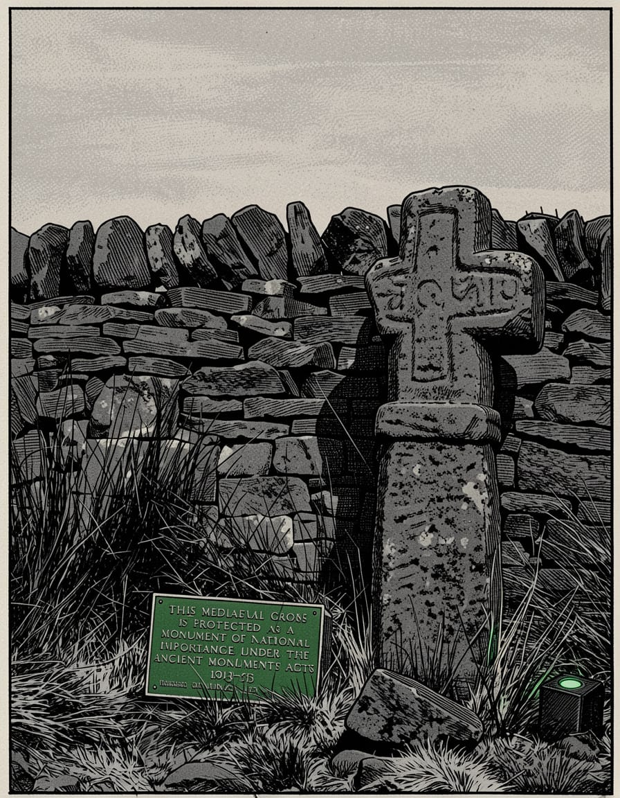
The cross was scheduled for protection as an ancient monument in 1934. It has subsequently been re-erected once again, after leaning in the saturated peat, and the dry-stone enclosure now around its base was constructed by the National Trust during that work. The cross continues to stand on what is generally accepted to be its original site.


Description

The cross is a single piece of coarse-dressed gritstone, standing 1.6 metres high, 0.49 metres wide across the arms and 0.29 metres wide at the base. The shaft is of rectangular section, with chamfered edges, surmounted by an integral equal-armed cross head above a band-like collar. The cross head is, in proportion, slightly large for the present length of the shaft, suggesting that the shaft has at some point been broken or shortened from a greater original length and that it may originally have been set into a now-lost socle stone.

The face of the shaft preserves faint traces of what appear to be Saxon-style knotwork; the chamfered edges, by contrast, are characteristic of post-Conquest dressing. The plain rear face carries the principal inscriptions: the initials and date 1810 from the re-erection, the earlier IG 1610 on the east arm of the cross head, and the additional sets of initials cut into the shaft. The left arm of the cross head, as one stands in front of it, is broken; the damage is not recent.


Role in the Saga — Cambion spoilers Contains plot reveals from Book One.

In Cambion, Edale Cross is identified as the probable location of an Orion static signals-relay installation, set up after Robert Knight's manifestation event of November 1995. The relay is identified by Mick Hargreaves, in Chapter Ten, in conversation with Declan Marsden at The Rail and Reservoir; Mick, who has been observing the rhythm of Orion's surveillance, reports having clocked it.

Someone's set up a relay near Edale Cross. They're listening, not talking. Mick Hargreaves, Cambion, Chapter Ten.

The relay's characteristics, on Mick's reading of the kit, are those of a former-signals-intelligence operator: low power, precisely positioned to exploit the line-of-sight corridors over the western edge of the Dark Peak toward Manchester, and configured to listen rather than transmit. Mick attributes it to Phillip Lawson, the resident Orion hand in Hope's End, whose dormant signals background has been re-activated since the manifestation event. The choice of Edale Cross is characteristic of the saga's use of real Peak District geography: a heritage waypoint maintained by the National Trust, photographed for ramblers' signage, walked past on a Sunday afternoon by hundreds of people in good weather, is the last place a covert signals installation would normally be searched for.

The installation is confirmed by Declan in his check-in from the High Street Phone Box later in the chapter — forty-eight days after Robert's manifestation, placing the call in late December 1995. Declan's report to Beowulf notes that Orion's active surveillance — the thermal van and the silver saloon previously stationed near Hope's End — was withdrawn the previous Wednesday, and that a static relay has been set in its place, ‘likely Edale Cross, listening but not transmitting’. The relay is not subsequently removed: removing it would reveal that Beowulf knows it is there.

The choice of Edale Cross marks the saga's quiet annexation of the surrounding moorland as operational territory. Before Mick's observation, Hope's End reads as an isolated case. After it, the surrounding country is revealed to be an observed and contested landscape, in which the surface tourist-geography hides a second geography of watchers and wires.


Trivia

  • The cross's alternative name, Champion Cross, derives from Campana, the medieval Latin name for the ‘open country’ ward of the Royal Forest of the Peak. The name is unrelated to the modern English sense of champion as a victor.
  • England preserves fewer than four hundred medieval wayside crosses in the National Heritage List; most are concentrated on Dartmoor and in the south-west. The Peak District holds a relatively small but well-preserved set, of which Edale Cross is among the most notable. Others include Lady's Cross on Big Moor, Whibbersley Cross on Leash Fen, and Robin Hood's Picking Rods near Charlesworth.
  • The cross stands on the line of an ancient packhorse route between the Hope Valley and the Cheshire Plain, at one of the higher points of the route's passage over the watershed. Before the modern road network, this was one of the principal east-west crossings of the central Peak.
  • The 1810 re-erection of the cross by Thomas Gee and his neighbours took place during the Napoleonic Wars, when much of the upland Peak was being newly enclosed and re-surveyed. The local criticism of Gee's carving his initials on a medieval monument is the earliest documented complaint of heritage vandalism connected to the stone.
  • The cross stands within the wider area of Kinder Scout, the moorland whose 1932 Mass Trespass is generally credited as the catalyst for the post-war national-park movement that produced, in 1951, the Peak District National Park — the United Kingdom's first.

Appearances

Title Role Notes
Cambion
Book One · Book of Thoth Saga
Referenced; Operational Background Identified by Mick Hargreaves in Chapter Ten as the probable site of an Orion static signals-relay; confirmed in Declan Marsden's check-in from the High Street Phone Box later in the same chapter. The cross itself never appears as a directly-set scene.