Kinder Scout

Kinder Scout — gritstone plateau on the southern edge of the Dark Peak; the highest point in the Peak District

Location Profile
Type Moorland plateau; highest point of the Peak District
Region Peak District, Derbyshire, England
Elevation 636 m (2,087 ft) at the summit cairn
Geology Namurian Millstone Grit (Kinder Scout Grit); blanket peat
Designations National Nature Reserve; SSSI; SAC; National Trust High Peak Estate
Notable Features Kinder Downfall (waterfall on western edge); the Edge gritstone rim; Edale valley to south
Historic Event Mass Trespass, 24 April 1932
First Appearance Cambion, Chapter Ten: Beautiful Lie

Kinder Scout

Gritstone moorland plateau; the highest point of the Peak District.


Overview

Kinder Scout, often referred to locally as ‘Kinder’, is a moorland plateau in the Dark Peak area of the Peak District National Park, in the High Peak borough of north-west Derbyshire, England. At 636 metres (2,087 feet) above sea level, its summit cairn is the highest point in the Peak District, the highest point in the East Midlands, and one of the more elevated summits in central England. The plateau measures some four square miles across the top.

Kinder is the principal moorland landmark of the central Peak. Its long southern escarpment, falling away to the Vale of Edale, is the first major ascent of the Pennine Way out of Edale village; its western edge, falling away to Hayfield, is the site of the celebrated Kinder Downfall waterfall and, on 24 April 1932, of the Mass Trespass that came to be regarded as the founding event of the British right-to-roam movement. The whole of the plateau and its surrounding edges has been a National Nature Reserve since 2009 and lies almost entirely within the National Trust's High Peak Estate.


Geography & Atmosphere

The plateau is roughly square in plan, oriented north-south, with its long sides defined by gritstone edges that drop precipitously to the surrounding moorland. To the south, the escarpment falls some 350 metres in roughly a mile to the floor of the Vale of Edale. To the west, the plateau falls to the Sett valley above Hayfield. To the north, Kinder merges into the wider blanket of Dark Peak moorland through the cols of Snake Pass and on toward Bleaklow. To the east, the gritstone edges run unbroken from Crookstone Knoll along Madwoman's Stones and Ringing Roger toward the Derwent reservoirs.

The plateau surface itself is a substantially level expanse of blanket bog, peat and cottongrass, broken by an irregular network of groughs — deep peat channels cut by water over the post-glacial period, often two or three metres deep, in which a walker becomes invisible from a hundred metres away. Hags of remnant peat stand between the groughs. The surface is treacherous in poor visibility; the OS map of the plateau warns explicitly against attempting to cross it in mist without compass and bearing. Several of the streams running off the plateau (Crowden Brook, Grindsbrook, the River Kinder itself) take their courses through groughs that cut to the underlying gritstone.

The edges — the perimeter ring of gritstone outcrops where the plateau drops away — are the principal navigational features. They are also the principal recreational ones: the long sweep of edge from Grindslow Knoll round to Crookstone offers some of the most-walked scenery in the central Peak, and the rock climbing on outcrops such as Ringing Roger and Madwoman's Stones is well-known to climbers of the Dark Peak grit tradition. The drop is invariably abrupt; the transition from level peat to vertical gritstone happens in a few feet, and walking the edges in mist requires care.

The weather on the plateau is its own. Wind speeds at the summit cairn can run double those in the valley below; rainfall is roughly twice the local Derbyshire average; the cloud-base sits on the plateau through much of the winter and on most days in any season. Snow lies on the summit for around fifty days a year, and persists in sheltered groughs into early summer. Visibility on the plateau, on a bad day, can be reduced to the next bog cotton.

Geology & Landscape

Kinder Scout is geologically composed of Namurian Millstone Grit — the coarse cross-bedded sandstone that gives the Dark Peak its name and its character — specifically the formation known as the Kinder Scout Grit, deposited some 318 million years ago in the deltaic environment of a large river system flowing south from the Caledonian uplands. The grit is interbedded with thin mudstone and shale partings, and the cyclical erosion of these softer beds beneath the harder grit caps is the principal mechanism producing the plateau's characteristic broken edges and the boulders and tors strewn across the moorland.

The plateau surface carries one of the most extensive areas of blanket peat in southern Britain. The peat began to accumulate in the early Holocene, around 7,000 years ago, on the level plateau where drainage was impeded by the underlying gritstone. The maximum peat depth on Kinder is around four metres. The peat is, in places, severely eroded — the legacy of nineteenth-century atmospheric pollution from the Manchester and Sheffield industrial belts, which killed off the Sphagnum mosses that maintain the bog, and of subsequent wildfires and overgrazing. The Moors for the Future partnership has carried out extensive peat restoration work on Kinder since 2003, re-vegetating bare peat with cottongrass and heather and blocking eroding groughs.

Of the plateau's smaller landscape features, the most notable is Kinder Downfall, a waterfall on the River Kinder where it falls thirty metres over the western edge of the plateau toward the Sett valley below. In dry conditions the falls reduce to a trickle; in strong winds blowing up the cliff, the falling water is visibly driven back uphill and atomised as spray, producing a plume that can be seen for some miles. The phenomenon is one of the principal local-weather curiosities of the central Peak.


The Mass Trespass, 1932

On Sunday 24 April 1932, approximately four hundred members of the British Workers' Sports Federation, organised in Manchester under the leadership of the twenty-year-old Communist Party activist Benny Rothman, gathered at Bowden Bridge quarry above Hayfield and walked up onto Kinder Scout via William Clough. Their declared purpose was to challenge the exclusion of the public from open moorland for the benefit of grouse-shooting by a small number of private landowners; their route was deliberately chosen to take them onto land from which the public was, at that date, legally barred. A smaller party of Sheffield ramblers, working in coordination, ascended the plateau from Edale via Jacob's Ladder; the two parties met briefly on the plateau before returning to their respective valleys.

The Hayfield contingent encountered the Duke of Devonshire's gamekeepers on the plateau; there were some minor physical exchanges; on their return to Hayfield, six of the trespassers were arrested. Five were subsequently imprisoned for breach of the peace and unlawful assembly, with sentences of between two and six months. The arrests, the imprisonments, and the public reaction to them are generally regarded as the catalyst for the post-war movement that produced, first, the National Parks and Access to the Countryside Act 1949, and second, the long process by which the principle of public access to open moorland was eventually established in statute by the Countryside and Rights of Way Act 2000.

The Mass Trespass is commemorated annually at Bowden Bridge. A plaque on the gritstone outcrop near the start of the William Clough path records the names of the imprisoned five; the surrounding moorland has been open-access ground since 2000.


Routes & Access

The plateau is approached from four sides. The classic ascent from the south, used by walkers of the Pennine Way, climbs from Edale village via either Grindsbrook Clough (the direct line, steep) or, in bad weather, Jacob's Ladder past Lee Farm and Upper Booth (longer but on a built path); the ascent gains some 500 metres in around a mile. From the west, the standard route is from Bowden Bridge above Hayfield, climbing William Clough to Kinder Reservoir and then up to the Downfall. From the north, the moorland is most readily accessed from Snake Pass (the A57 between Sheffield and Manchester), with paths leading south onto the plateau via the col below Mill Hill. From the east, the approach is via the Edale Skyline edges from Hope or via the Ladybower side.

Once on the plateau, navigation is by edge-following in clear weather or by precise compass-bearing in mist. The traditional crossing routes — the so-called Kinder traverse from Grindsbrook to Crowden via the plateau crossing — are now substantially marked by re-vegetated paths, but in bad visibility the plateau remains an environment in which even experienced walkers can become lost. The conventional advice is that nobody who is not confident with map and compass should attempt to cross the plateau in mist alone.


Role in the Saga — Cambion spoilers Contains plot reveals from Book One.

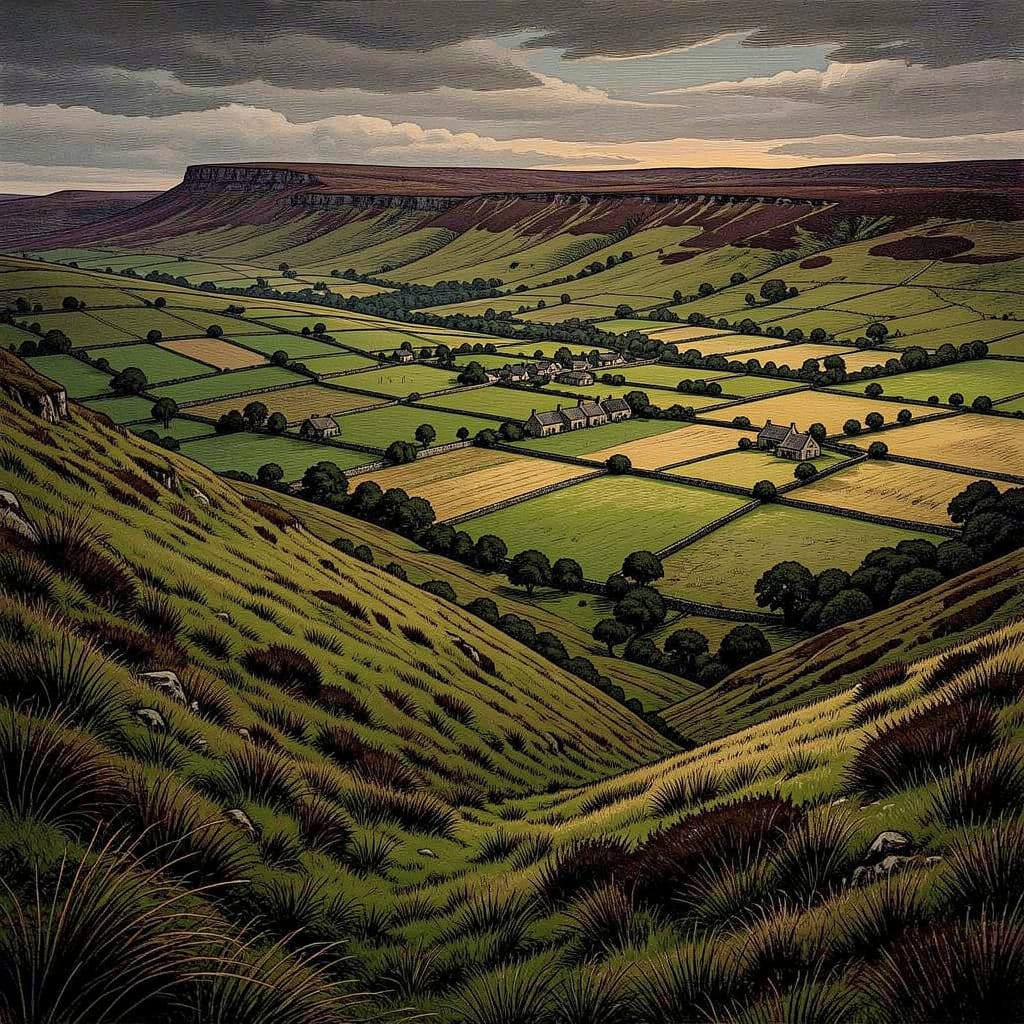
Kinder Scout is the northern skyline of Hope's End and the principal piece of operational ground that Ben Knight patrols across the saga. The high ground above the village is the most likely approach for anyone coming at the family from the north without being seen, and Ben knows its routes, fall-backs and dead ground as a working environment.

The night on Kinder. In Chapter Thirty: Half the World Away, the saga's most consequential single Kinder Scout scene unfolds — not on the plateau itself but in the Knight kitchen, where Ben returns home wounded after a night on the moor. The cover story has been one he gave Toby earlier — a shade spooking sheep near Kinder Scout, to be checked. The truth, drawn out of him at the sink over a whisky bottle he does not pour, is that he spent the night being hunted by a team of three Orion operatives working a sweep grid across the plateau. The kit: scopes that do not flare, suppressed cans, no chatter, no heat signatures. Former-signals-intelligence equipment, in the assessment Ben delivers in the kitchen: they've had twelve years and a budget. I've had a shed.

The exchange that follows is, in compressed form, the saga's clearest single statement of what Ben is, what he can do, and why he does not. Toby says it as a flat observation, not a question:

You could've had ‘em. Turned half o' Kinder into glass if you wanted. Toby Knight, Cambion, Chapter Thirty.

Ben's answer is not a denial. It is operational logic. To light up half the ridge would be to give every thermal-imaging eye from the central Peak to London a clean signal — which is exactly what Orion wants. He could have killed the three operatives silently — just pushed the air around him until his lungs boiled, no noise, no bullet. He did not. If he had missed one shot, if there had been a fourth man he had not clocked, a thermal anomaly would have been called in and the scout team would, by the following week, be something else entirely. So he went belly-down in a ditch with sparks dying around his fingertips and let the sweep complete its grid.

The conclusion he delivers in the kitchen is precise: Beowulf is now a dead line — tone, then click. The Knights have been blacklisted since 1987 and the events at Shoreham Haven Hospital. Orion is at the fence. The Quiet — the small village invisibility that has held since the relocation — is running out. Ben, who can turn half a moorland plateau into glass, cannot do so without ending the only thing that has kept his family alive for eight years. Kinder Scout is the ground on which he discovers, in the most precise possible terms, the extent of what he cannot use.

The mist that does not consult the date. Later in the novel, in Chapter Forty: Every Breath You Take, after a separate operational crisis has been narrowly weathered, the narrator returns to the plateau in an oblique register: the Peak District had no opinion on this; the gritstone was older than the calendar, and the mist came off Kinder Scout just as it always had, without ever consulting the date. The line establishes Kinder's function across the saga: the fixed point above the valley, indifferent to the human activity beneath it, present whether or not anyone is looking. The reassurance and the threat of this fact are equally available depending on the reader's mood.


Trivia

  • The name Kinder Scout is of uncertain origin. The most commonly proposed etymology derives Kinder from an Old British cunetio (‘water’ or ‘great hill’) and Scout from the Old Norse skuti (‘an overhanging rock’), giving roughly ‘high overhang above the water’. The waterfall on the western edge, Kinder Downfall, may preserve the original referent.
  • Kinder Downfall is, in dry conditions, a thin trickle; in strong westerly winds, the falling water is driven back upward by the wind hitting the cliff and atomised as spray, producing a visible plume that can be seen from several miles. The phenomenon is one of the more frequently photographed local-weather curiosities of the Peak District.
  • The 1932 Mass Trespass on Kinder Scout is widely regarded as the founding event of the British right-to-roam movement. The route the Hayfield trespassers took up William Clough is still walked on its anniversary each year. A plaque on the gritstone at the foot of the path commemorates the action and lists the trespassers who were imprisoned for unlawful assembly and breach of the peace.
  • Kinder Scout is geologically the type locality of the Kinder Scout Grit, the coarse cross-bedded Namurian sandstone of the Millstone Grit Group, which crops out widely across the Dark Peak. The grit was deposited around 318 million years ago in the deltaic environment of a large river system flowing south from the Caledonian uplands of what is now Scandinavia.
  • The active peat restoration on Kinder Scout, undertaken by the Moors for the Future partnership since 2003, is one of the largest blanket-bog restoration projects in Europe. The Sphagnum re-introduction programme has re-established living bog on substantial areas of previously bare peat, with consequences for the plateau's carbon storage, water management and ecological recovery.
  • Snow lies on the plateau for an average of fifty days a year; in sheltered groughs and on the north-facing edge, it can persist into late May or June, well after the snow line in the surrounding valleys has retreated. The first day of consistent valley-floor snow in the upland Peak each winter is sometimes referred to locally as Kinder day, in recognition of the altitude difference.

Appearances

Title Role Notes
Cambion
Book One · Book of Thoth Saga
Operational Terrain; Skyline Presence The northern skyline of Hope's End; the principal piece of operational ground patrolled by Ben Knight; site of the off-page night encounter with three Orion operatives debriefed in the kitchen scene of Chapter Thirty: Half the World Away. Returned to in narrator's voice in Chapter Forty: Every Breath You Take as the mist that does not consult the date.